Open Foris Collect
Design smarter surveys. Collect better data.


Latest Version: 1.22.3 (Last Updated: 2025-09-24)
Open Foris Collect is the trusted desktop solution for field-based inventories worldwide. Proven through hundreds of real-world surveys, it offers a robust environment for designing complex questionnaires, managing diverse data types, and enforcing advanced validation rules. With its user-friendly interface and multilingual support, Collect helps teams turn field observations into reliable, consistent information — empowering better decisions on land, forest, and resource management.
Collect seamlessly integrates with other Open Foris solutions, such as Collect Earth for interpreting land use and land cover through satellite imagery. Data from Collect can also be migrated into Arena for multi-cycle inventories and long-term monitoring.
Open Foris Collect is a mature and field-proven application. While it will continue to receive occasional maintenance and bug fixes, no major updates or new features are planned.
For users developing new surveys not intended for Collect Earth, we recommend transitioning to Arena, the next-generation platform for survey design, data management, and analysis.
Key Features

Intuitive Interface
Designed for efficiency and clarity, Collect offers a straightforward desktop interface that makes complex survey management accessible to technical and non-technical users alike.
Flexible Survey Design
Build inventories that match your exact needs. Collect allows users to design surveys from scratch or adapt pre-built templates, with data entry forms automatically generated from survey metadata.
Advanced Validation Rules
Define and apply complex validation logic to ensure consistency and reliability. Real-time validation minimizes errors at the point of entry, supporting rigorous data quality control.
Comprehensive Data & Multilingual Support
Handle a wide range of data types — text, numbers, coordinates, dates, files, and taxonomic data — including calculated attributes. Collect supports multilingual surveys (English, Spanish, Portuguese, and more), adapting seamlessly to international teams.
Integrated Data Quality Management
Ensure accuracy through a complete “data entry and cleansing” workflow. Real-time checks, validation reports, and the built-in Data Cleansing Toolkit make it easy to detect and correct inconsistencies across large datasets.
Connected Field-to-Office Workflow
Deploy surveys from Collect to Collect Mobile for efficient field data capture, then re-import collected data for centralized review and analysis — no manual transcription required.
Rich Metadata & Interoperable Formats
Built on the XML-based Inventory Data Metamodel (IDML), Collect supports complex, nested survey structures and multiple coordinate reference systems. Export options include XML, CSV, and SQL database formats for smooth integration with analytical and reporting tools.
Designed For
Open Foris Collect supports a broad community of users involved in field data collection for forestry, environmental monitoring, biodiversity assessment, socio-economic research, and land-use management.
It combines robust desktop survey design with offline mobile data capture (through Collect Mobile), delivering an end-to-end workflow for accurate, customizable field inventories — even without internet connectivity.
Key target audiences and use scenarios include:
National Forestry Agencies
Implement standardised National Forest Inventories, forest resource assessments, and monitoring surveys. Collect supports multi-user workflows, strong validation procedures, and data structures compatible with national reporting frameworks.
Environmental &
Biodiversity Conservation
Used by conservation organisations, research institutes, and environmental agencies for species inventories, habitat monitoring, and biodiversity assessments. Collect’s metadata-driven survey design and geo-referenced data capture accommodate complex ecological protocols.
Climate Reporting
Facilitates transparent data collection for forest carbon accounting, deforestation monitoring, and land-use change analysis, supporting national and international climate reporting commitments
Socio-economic &
Livelihood Data
Empowers governments, NGOs, and researchers to design and implement socio-economic surveys. Collect’s flexible questionnaires capture household, community, and land management data efficiently, even in remote locations.
Agroforestry & Sustainable
Land Management
Adopted by agricultural ministries, extension services, and farmer networks to gather detailed field data on crop systems, agroforestry practices, and land management — strengthening evidence-based decision-making for sustainable agriculture.
Workflow & Architecture
Workflow
A workflow that guides users from survey design to data validation, analysis, and reporting. Each phase supports a transparent, repeatable process designed for accuracy, collaboration, and long-term usability.
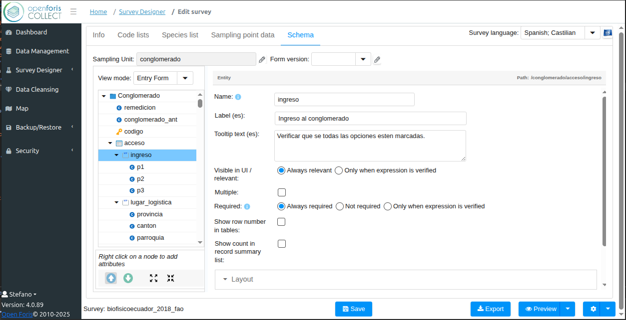
Users begin by creating a new survey or importing an existing template through the Survey Designer interface.
-
Create or Import Survey: Users begin by creating a new survey or importing an existing template through the Survey Designer interface.
-
Hierarchical Entity Modeling: Define entities such as plots, subplots, trees, or soil samples, and their relationships within the survey.
-
Variables & Code Lists: Establish variables, classifications, and lookup tables (e.g., species codes, land classes) to ensure harmonization across datasets.
-
Validation Logic: Set up range checks, required fields, logical constraints, and custom code lists to prevent data inconsistencies.
-
Documentation: All survey definitions are stored in IDML (Inventory Data Management Language), ensuring full traceability and compatibility with other Open Foris tools.
Once the survey structure is defined, authorized users can enter data through a guided, responsive interface optimized for large datasets.
-
Role-Based Access: Permissions define who can view, edit, or approve specific survey components.
-
Assisted Data Entry: Auto-complete fields, lookup popups, and contextual help texts support fast and accurate input.
-
Instant Validation: Automated checks provide real-time feedback, flagging errors and warnings directly in the form.
Supervisors review and refine data using integrated tools for validation, correction, and communication with field teams.
-
Validation Dashboards: Summaries highlight flagged records, missing values, and inconsistencies.
-
Supervisor Review Mode: Filter records by status, user, or error type for targeted quality control.
-
Batch & Manual Editing: Apply corrections, add notes, or temporarily exclude records for further review.
-
Iterative Cleansing: Multi-cycle validation allows continuous improvement and dialogue between data collectors and supervisors.
-
Preparation for Export: Once quality checks are complete, datasets can be locked or marked as final to prevent further edits.
-
Multi-Format Export: Cleaned datasets are exportable in standard formats (CSV for tabular data, XML for structured records, or database dumps for larger projects).
-
External Integration: Exported data can be fed into geographic information systems (GIS), statistical analysis software, or national reporting templates to meet reporting requirements.
Architecture
- Platform: Desktop application supporting Windows, Linux, and Mac OS X.
- Programming Stack:
- Java-based backend (including Spring Framework 5.3.x)
- React JS and ZK framework for UI components
- Apache Maven for build and dependency management
- Architecture:
- Modular structure with components such as collect-base, collect-core (used by collect-mobile), collect-rdb, collect-server, and collect-webapp
- Data Handling:
- Supports multiple data types: text, number, boolean, date/time, coordinate, files, and taxon
- Complex validation rules (distance, patterns, comparisons)
- Metadata-driven: uses XML-based Inventory Data Metamodel (IDML) for survey structure and metadata
- Storage: Utilizes local database solutions (e.g. SQLite) to store survey forms and collected data.